Cumberland Gap National Historical Park

  • address 91 Bartlett Park Road , Middlesboro, KY 4096536.5996401-83.6944992

Cumberland Gap, the first gateway to the west, the buffalo, the Native American, the long hunter, the pioneer all traveled this route through the mountains into the wilderness of Kentucky.

Cummins Nature Preserve

  • address Pickett Lane, Maysville , KY 4105638.6790014-83.8032404

Cummin’s Nature Preserve is a 100 acre preserve located just minutes from downtown Maysville. Enjoy miles of hiking/walking paths, wildlife viewing, picnic area, playground and primitive camping.

Daniel Boone National Forest Cumberland Ranger Station

  • address 2375 KY 801 South, Morehead, KY 4035138.1231258-83.5258479

The office, located on Cave Run Lake, provides maps and information about the Daniel Boone National Forest. It also serves as the district office for Cumberland Ranger District.

Deer Haven

  • address 157 Spencer Trail Rd, Beattyville, KY 4131137.6282079-83.6994899

Escape to nature and stay at this idyllic Beattyville vacation rental cabin. Aptly named, 'Deer Haven Cabin' is set in a peaceful forest filled with abundant wildlife and views of the rolling hills. The 3-bedroom, 2-bathroom abode offers 8 guests 3 outdoor areas with easy access to outdoor recreation. You'll be 18 miles from Red River Gorge, 12 miles from Natural Bridge State Resort Park and minutes from rock climbing, zip lining, kayaking, horseback riding, fishing, boating and more!


Dog Slaughter Falls

  • address Forest Service Road 195, Corbin, Kentucky 4070236.858184.3113

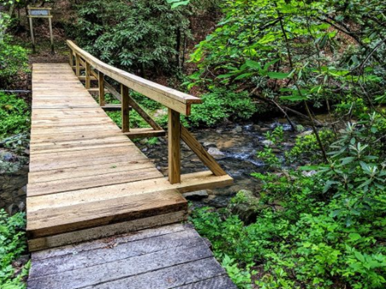
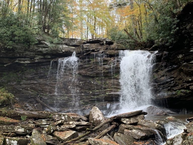
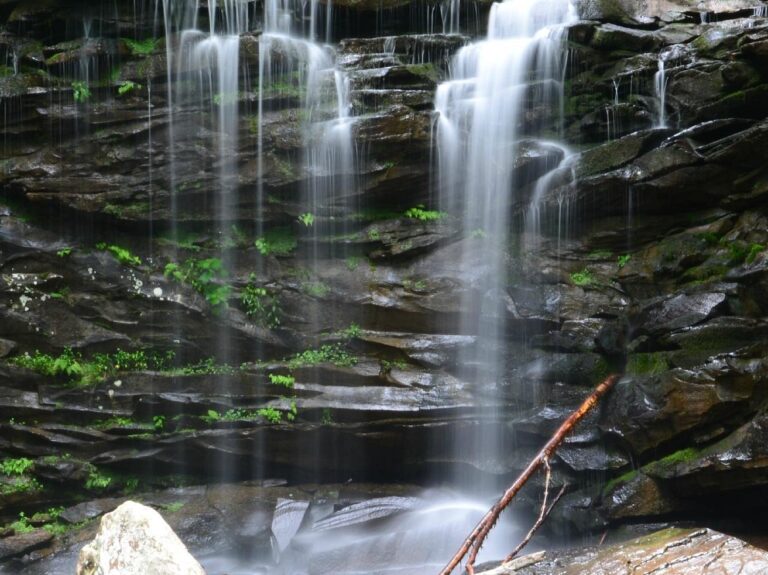
Located just over a mile from the nearest trailhead, Dog Slaughter Falls is one of the most beautiful waterfalls in the Daniel Boone National Forest.

That’s actually a high honor, because there are a lot of waterfalls to choose from within the national forest. But it’s not an exaggerated honor. Dog Slaughter Falls is stunning, despite its morbid name.

The fourth hike of the Twenty Week Hiking Challenge visits Dog Slaughter Falls, and the greatest thing about this hike is that — unlike some trails that offer a mundane hike to reach a picturesque feature at the end — getting to the waterfall is half the fun.

The trail to Dog Slaughter Falls travels along Dog Slaughter Creek, an absolutely stunning mountain stream that empties into the Cumberland River just beyond the waterfall. The hike is a gorgeous stroll through nature, the trail meandering through a hemlock and rhododendron forest for the entirety of its route.

Droop Mountain Battlefield State Park

  • address 683 Droop Park Road, Hillsboro, WV 2494638.1353972-80.2131261

A peaceful park with a panoramic view from the iconic Droop Mountain Tower, now marks the spot where one of West Virginia’s largest and last important Civil War battle was fought on November 6, 1863. The decisive victory of Union forces under General William W. Averell over the Confederate army under General John Echols ended serious efforts by the Confederacy to control West Virginia.

Falcon Overlook

  • address 4436 Hwy 119 S, Whitesburg, KY 4185837.1184318-82.8268265

Falcon Overlook- Located where the old Falcon Inn used to be, this overlook is dedicated to Community Trust Bank. The elevation at Falcon Overlook is 2,557 feet. Etched in the concrete is the date 1948 and the name Doyle. This location was an overgrown building foundation with only a chimney standing.

Falls of Hill Creek

  • address 932 N Fork Cherry Road, Richwood, WV 2626138.2473344-80.5251505

Three waterfalls at the Falls of Hill Creek cascade over rock layers of sandstone and shale. A 3/4 mile trail provides access to the falls, including a paved, barrier-free trail to the first falls. This area is located six miles west of the Cranberry Mountain Visitor Center. A scenic forest trail leads into a narrow Gorge containing 3 waterfalls, the largest of which is 65 feet high, is the second highest waterfall in West Virginia.

Falls of Hills Creek

  • address Hill Creek Falls Rd, Hillsboro, WV 2494638.1795858-80.3391578

Tucked away in a narrow gorge just off the Highland Scenic Highway is a hidden treasure known as the Falls of Hills Creek Scenic Area. This popular 114 acre area contains three waterfalls - 25 feet, 45 feet, and 63 feet. The lower falls, at 63 feet is the second highest waterfall in West Virginia.

Accessibility:
The first 1700 feet of trail is a paved and has a wheelchair accessible path to the upper falls viewing platform.

Directions:
From the North and East via Interstate 79, use Exit 57 onto US Route 19 South to State Route 55. Take WV 55 through Richwood to the Falls of Hills Creek. Approximately 65 miles from Exit 57.

From South and East via Interstate 64 use Exit 169 onto US 219 North to State Route 39/55. West on WV 39/55 to Falls of Hills Creek. Approximately 42 miles from Exit 169 in Lewisburg.


Fish Pond Lake

Fish Pond Lake

  • address 475 Fish Pond Dr, Jenkins, KY 4153737.1596623-82.6773092

Fish Pond Lake is a gorgeous vista. Nestled in the woods of the Central Appalachian mountains this park provides beautiful scenery, good fishing, camping, photo ops hiking and more

Flag Rock Recreation

  • address Flag Rock Road, Norton, VA 2427336.915362-82.6313869

The thousand-acre park includes 25 developed acres that offer spectacular views, mountain biking/hiking trails, fishing, canoeing/kayaking, and rock climbing.

Flag Rock/High Knob Recreational Area

Flag Rock/ High Knob

  • address Flag Rock Road, Norton, Virginia 2427336.915362-82.6313869

Flag Rock Recreation Area is located three miles above downtown Norton on the lower slopes of High Knob. The thousand-acre park includes 25 developed acres and a variety of outdoor adventures. Please note restroom facilities in the park are open seasonally. Restrooms are open when Flag Rock Campground is open during the spring and fall months. Opening dates for the campground and restrooms are dependent on the weather. 

Flat Lick Falls

  • address Flat Lick Falls Recreation Area, McKee , Kentucky 4044737.3724695-83.93826279999999

Flat Lick Falls Scenic and Recreation Area is tucked into the hills of southern Jackson County and consists of recreational facilities, including primitive camping (check with us about RV camping), picnic shelter and restrooms, 86.09 acres of wooded land, cliffs and Flat Lick creek running through the middle of the property with a 28-foot water fall emptying into a large pool at the bottom of the falls. The creek flows into the Laurel Fork Creek.  The falls can be viewed up close via the meandering paths along the cliff line including a paved path leading to a wheelchair accessible viewing platform.